With the use of mechanisms for determining the coordinates of subscriber devices in real time, WNAM Radar becomes a classic Real-Time Location Tracking, RTLS-system.
We use our own mathematical algorithms that allow us to calculate the location of the source (smartphone) in space when receiving data from several radars. The minimum number of radars is three, the optimal one is about 7 radars that simultaneously receive data about one signal source.
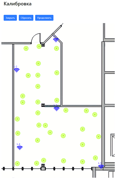
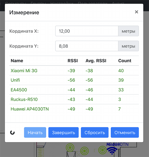
We use the unique technology of preliminary “calibration” of the room, when at specified points on the floor plan the signal level is measured from a device specially developed by us – the calibrator. Then, our algorithms calculate the “radio profile” of the room where the radars are installed to more accurately determine the coordinates of mobile devices. The accuracy of determining the coordinates depends on various factors and averages 3-5 meters. A more accurate location cannot be performed due to the restrictions imposed by physical laws, and it has no practical application.
The uniqueness of RTLS implementation in our WNAM Radar lies in the support of both cheap OpenWrt radars and professional access points Cisco, Aruba, Huawei, Extreme, Ruckus, which already have built-in data collection tools.
WNAM Radar collects data from access points in a standard manner prescribed by the manufacturer (no flashing), but you do not need to purchase expensive RTLS tools from equipment vendors or other third-party manufacturers. WNAM Radar fully emulates the behavior of the following software products:
- Cisco – Connected Mobile Experience (CMX), DNA Spaces
- Aruba – Analytics and Location Engine (ALE)
- Huawei – CloudCampus WLAN Location
- Ruckus – SPoT Smart Positioning Technology (vSPoT)
- Extreme – ExtremeLocation
At the moment, we do not support the collection of data from iBeacon beacons and BLE tags, as well as work with specialized access points using the Angle-of-Arrival, AoA mechanism. Our studies show that there is no significant business benefit in their application.
The configuration of sending data to the WNAM Radar RTLS system is carried out on the access point controller in a regular way, and this takes less than a minute. After that, all access points connected to the controller begin to send data about the MAC addresses observed on the radio. WNAM Radar automatically finds all access points, and enters them into its database.
After the data began to be collected, the room map is loaded, access points are placed on it, calibration is carried out, WNAM Radar is completely ready to work as an RTLS system. You will get the opportunity:
- build heatmaps, i.e. congestion density
- define a track for moving a given user in a room
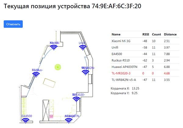
- determine the current location of the device with a given MAC address (as below)
- sending notifications to administrators and to the CRM system
- sending notifications to the user himself in an SMS message or in a Push notification to a mobile application